16 01, 2018

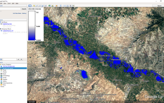
Frequent error while importing HEC-RAS data into ArcGIS (using GeoRAS)

By |2018-01-16T15:09:00+00:00January 16th, 2018|BLOG|0 Comments

HEC-GeoRAS is a tool, that allows processing geospatial data in ArcGIS using a graphical user interface (GUI). The interface capabilities include operations like preparation, import and export data from HEC-RAS into ArcGIS, as well as processing of the exported HEC-RAS data. While importing HEC-RAS data to ArcGIS (using GeoRAS), the appearance of errors is a [...]

12 01, 2018

3D visualization of vector and raster data with ArcGIS Pro

By |2018-01-12T15:58:01+00:00January 12th, 2018|BLOG|0 Comments

ArcGIS Pro is a big step forward in the visualization, analytics, image processing, management and integration of spatial data. One of the greatest advantage of using ArcGIS Pro is the possibility of visualize your data in 2D and 3D separately or simultaneously. This can be made in a simple and easy way, through the function [...]

8 01, 2018

Delineate snow using Normalized Difference Snow Index, Sentinel 2 and QGIS

By |2018-01-15T10:45:05+00:00January 8th, 2018|BLOG|3 Comments

The Sentinel-2 mission is a land monitoring constellation of two satellites that provide high resolution optical imagery and provide continuity for the current SPOT and Landsat missions. Sentinel-2 satellite data is provided in multiple levels and stages of processing, from raw data to already TOA, geometric and radiometric calibration (Level-0, Level-1A, Level-1B and Level-1C). SENTINEL-2 [...]

5 01, 2018

New 3D capabilities with QGIS 3.0 (QGIS 2.99 development release)

By |2018-01-09T08:23:53+00:00January 5th, 2018|BLOG|0 Comments

There is a lot of enthusiasm and excitement about the new QGIS 3.0 release. The project is under way and the GIS community is waiting for its release. The upgrade from version 2 to version 3 is anticipated to bring countless new features and capabilities. It is expected to improve the current QGIS functionality and [...]

12 12, 2017

Import ArcMap documents in ArcGIS Pro

By |2018-01-09T18:45:20+00:00December 12th, 2017|BLOG|0 Comments

If you’re a longtime ArcMap user, you naturally want to know whether you can bring your work into ArcGIS Pro, the latest evolution of ArcGIS Desktop software. The answer is yes! In this tutorial, you’ll learn how to import a map document from ArcMap, and evaluate the results. For example, we have an .mxd file, [...]

13 11, 2017

What is ArcGIS Pro@

By |2018-02-13T11:20:13+00:00November 13th, 2017|BLOG|0 Comments

ArcGIS Pro is a new professional desktop GIS application, that’s part of the ArcGIS for Desktop collection of software. ArcGIS Pro was built using the best aspects of ArcMap, ArcCatalog, ArcScene and ArcGlobe. It is a new technology developed to meet the needs of a continuous growing GIS community and includes scientific tools for answering [...]

2 11, 2017

Download and Instal ArcGIS Pro

By |2018-02-13T11:20:39+00:00November 2nd, 2017|BLOG|0 Comments

ArcGIS Pro is a modern, fast and powerful software. Developed for 64-bit operating systems, it provides access to a wide range of GIS tools and functionalities. Technologically ahead of everything else on the market, ArcGIS Pro will take your experience as a Geographical Informational Systems professional to the next level. ArcGIS Pro integrates new capabilities, [...]

23 10, 2017

Mapping floods using open source data and software

By |2018-05-11T07:37:52+00:00October 23rd, 2017|BLOG|6 Comments

Over the last decades, the world of free and open source geo-spatial data and software, has experienced a rapid growth. The concept gained value among professionals from different fields of work, due to its availability and interdisciplinarity. Mapping and understanding the features of the earth became easier. Natural disasters like floods are happening worldwide. Due to [...]

13 05, 2016

What is an SDI?

By |2017-11-06T08:51:11+00:00May 13th, 2016|BLOG|0 Comments

We can define an SDI (Spatial Data Infraestructure) as a computer network system composed by a group of resources (catalogues, servers, programs, data, applications, WebPages, and so on) that manage the Geographic Information such as maps, orthophotography, satellite images, toponims, etc. They are available to download online. This information supplies interoperability conditions (rules, specifications, protocols, [...]

Title

Go to Top