6 03, 2018

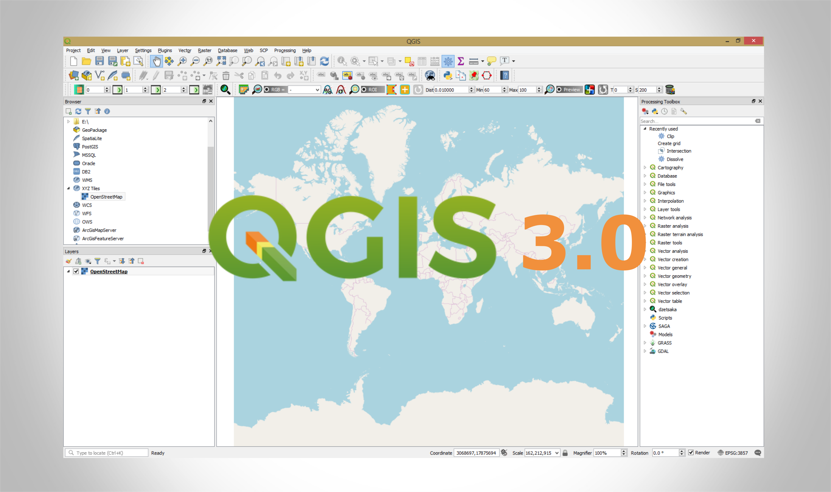
How to add OpenStreetMap Basemaps in QGIS 3.0

By |2018-03-07T10:38:13+00:00March 6th, 2018|BLOG|7 Comments

QGIS 3 has a new plugin architecture, meaning that plugins are not immediately available/compatible with this new version. The QGIS OpenStreetMap Plugin is a plugin for the desktop GIS application QGIS. With the release of the new QGIS 3.0 version this plugin it is not available yet. We will have to wait for a new release of the [...]

22 02, 2018

QGIS 3.0 will be released tomorrow 23.02.2018

By |2018-02-22T12:32:35+00:00February 22nd, 2018|BLOG|0 Comments

23.02.2018 it is a big day for all QGIS users. After a long wait QGIS 3.0 will be finally released. According to QGIS Road Map the new version will be launched tomorrow. Its really a big thing if we take into consideration that there has not been any major releases since 2013 when version 2.o came [...]

21 02, 2018

How to download and install PostGIS via OpenGeo Suite

By |2018-02-21T12:24:30+00:00February 21st, 2018|BLOG|0 Comments

OpenGeo Suite is a full geospatial software stack that helps you compose, style, publish, and manage maps and data with ease. You can get PostGIS/PostgreSQL and other web GIS utilities in a single and fast installation using the OpenGeo Suite package installer. If you do not want all OpenGeo Suite capabilities and software that come along [...]

7 02, 2018

Differences in the developing of 3D cartographic viewers with Cesium and ArcGIS API for JavaScript

By |2018-02-07T13:57:55+00:00February 7th, 2018|BLOG|0 Comments

In this exercise we will try to compare two of the best 3D Web Mapping APIs that currently exist on the market. We will focus on the main differences when it comes to data modeling, processing, symbolization and visualization. On the one hand, The JavaScript API is performing better when it comes of visualization and [...]

6 02, 2018

EO Browser a web tool for Earth observations

By |2018-02-13T09:20:51+00:00February 6th, 2018|BLOG|5 Comments

Sinergise EO Browser is a free spatial data visualization tool which allows users to search and study a vast amount of satellite imagery. It brings together products like Sentinel-2 and Sentinel-3, ESA’s archive of Landsat 5, 7 and 8, global coverage of Landsat 8, and Proba-V. All of these can be found in the same place, providing a full resolution [...]

1 02, 2018

Use ArcGIS tools for 3D mapping – How to fill space between layers?

By |2018-02-01T16:55:56+00:00February 1st, 2018|BLOG|0 Comments

If you have two raster’s (digital elevation models) of the same area but they are displaying the area in two different moments of time, it is possible to fill up the space between them and obtain valuable data about the differences that occurred in time or due to an anthropic activity, for example a mining [...]

30 01, 2018

What is Google Earth Engine and how you can use it?

By |2018-01-30T16:16:23+00:00January 30th, 2018|BLOG|5 Comments

One of the latest application launched by Google is Google Earth Engine, an advanced cloud-based geospatial processing platform, designed mainly for planetary-scale environmental data analysis. It combines a multi-petabyte catalog of satellite imagery and geospatial datasets, which allow users to visualize, manipulate, edit and create spatial data in an easy and fast way. It incorporates [...]

26 01, 2018

Easy way to download Sentinel-2 images using QGIS SentinelHub Plugin

By |2018-01-26T13:08:01+00:00January 26th, 2018|BLOG|3 Comments

QGIS SentinelHub plugin from Sinergise is a fantastic tool which allows us to connect to Sentinel data server, visualize, analyze and even download satellite images, all of these using only our Desktop QGIS graphic interface. In addition, it offers interesting capabilities, such as downloading images from a specific range of time, with a specific percentage [...]

22 01, 2018

Simple methodology for water data extraction using QGIS and Sentinel 2 images

By |2018-01-23T08:40:37+00:00January 22nd, 2018|BLOG|1 Comment

Sentinel-2 satellite data proved to be a reliable source of information regarding the monitoring of Earth features and phenomena’s. With a 10 m geometric resolution is the best optical satellite data available free of charge. The temporal resolution is also performing well, the satellites in the Sentinel-2 constellation provide a revisit time of 5 days. [...]

Title

Go to Top