A coordinate system is responsible for displaying your data in the right location. Understanding how to properly work with Coordinate Systems can save unnecessary work and reduce the errors you may encounter in the development of the project. Lets see a simple example regarding this matter.
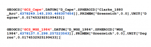
We have two layers that represent the country limit of South Africa. One layer is found in Geographic Coordinate System: GCS_Cape, Datum: D_Cape and the other in Geographic Coordinate System: GCS_WGS_1984, Datum: D_WGS_1984.
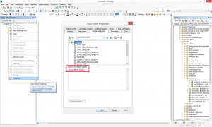
When you open a blank map document in ArcMap, if you go in the Table of Contents, to the Data Frame proprieties you will see that no coordinate system is set.
Here you can set a preferred Coordinate System that will affect the data frame proprieties. All the layers you will load after you set a Coordinate System will be projected on the fly to the selected coordinate system.
If you do not set any preferred Coordinate System, when you will load a layer in the map document, the projection of this layer will be set as data frame Coordinate System.
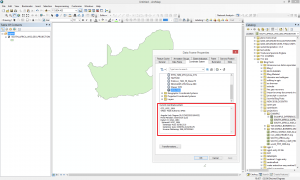
Step 1: Load in ArcMap the South Africa country limit that has as Geographic Coordinate System: GCS_WGS_1984, Datum: D_WGS_1984. Then check the data frame proprieties again. You will see that this one took the Coordinate System of the layer just opened GCS_WGS_1984.
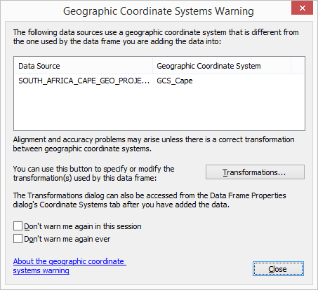
Lets try now to open the other layer mentioned above, the country limit of South Africa but in a different Coordinate System: Geographic Coordinate System: GCS_Cape, Datum: D_Cape.
When loaded a Geographic Coordinate System Warning appear. This means that the layer you want to load has a different Geographic Coordinate System and a different datum.
ArcMap warns you that in order to align this data properly some parameters must be set.
Let ignore this message and click Close.
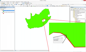
In the first place the layer seem to overlay perfectly. Lets make a zoom and check it. We will notice that the layers are not properly overlaid. Measuring the distance between one and another we get approximately 50 m of difference.
The next step will consist in removing the last loaded layer the country limit of South Africa but in a different Coordinate System: Geographic Coordinate System: GCS_Cape, Datum: D_Cape.
Try loading the layer one more time but this time we will configure some parameters in the Geographic Coordinate System Warning that will appear.
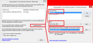
Convert from GCS_Cape into GCS_WGS_1984. Then you have to chose a proper Geographic Transformation Cape_To_WGS_1984_1.

We can observe that the layers are perfectly overlaid.
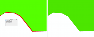
Before and after setting the parameters in the Geographic Coordinate System Warning.
Quality training taught by professionals
RECOMMENDED COURSE


Leave A Comment