Using the tool “Geotagged photos to points”, it is possible to observe the geographic location of images through the creation of a point layer from geotagged photos. This tool reads information related to the photos coordinates (JPEG or TIFF) saved in the metadata file “Exif”.

Geotag adds geographic information to images, video files, etc, allowing theirs positioning.
Photography cameras with GPS and Smartphones include such spatial information automatically to the EXIF metadata. EXIF data are included inside the image. It is possible to read this information right clicking the image and then selecting the tab “Summary”.
The tool “Geotagged photos to points” generates an entity class expressed in GPS coordinates, appearing 3 fields in its attributes table:
- The access route to the photo
- The name of the photo
- The date / time field that registers date and time in text format. It is possible to transform it to a date/time format with the tool “Convert the time field” which can correlate time data.
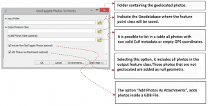
To do so, we must save all geolocated photos in a folder and follow the steps suggested by the tool.
Quality training taught by professionals
RECOMMENDED COURSE


Good