QGIS 3 has a new plugin architecture, meaning that plugins are not immediately available/compatible with this new version.
The QGIS OpenStreetMap Plugin is a plugin for the desktop GIS application QGIS. With the release of the new QGIS 3.0 version this plugin it is not available yet. We will have to wait for a new release of the plugin that will be compatible with QGIS 3.0.
Searching for OpenLayers plugin in the new QGIS version will not demonstrate any result.
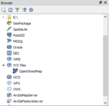
To easily bring an OpenStreetMap layer into our QGIS project, we can use the option XYZ Tiles to load it. Raster tiles in XYZ format are supported within WMS data providers, allowing the display of different basemaps from other sources without requiring plugins like QuickMapServices or OpenLayers. This feature was developed by Martin Dobias.
Lets see how you can do this in QGIS 3.0.
XYZ Tiles function is available in QGIS 3.0 and can be accessed from the Browser panel.
If the OpenStreetMap raster tile it is not available, follow the next steps.
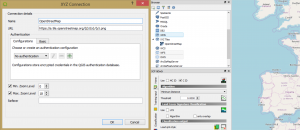
- Go to https://wiki.openstreetmap.org/wiki/Tile_servers, here you will find a list of online raster tile servers based on OpenStreetMap data.
- Select a OpenStreetMap’s Standard tile layer an copy the URL: https://a.tile.openstreetmap.org/${z}/${x}/${y}.png.
- Then, go to XYZ Tiles > Right click > New Connection > Paste the URL > Name to the connection (do not forget to delete the $ signs when pasting the URL). We will call it OpenStreetMap. Click Ok.
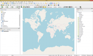
Now the connection is created and the OpenStreetMap’s Standard tile layer can be added and visualized and navigate through.
Quality training taught by professionals
RECOMMENDED COURSE


Thanks Catalin. I tried this and can load the tiles but the text is too small to see. Not sure if it is my laptops resolution (3200×1900), but is there a way to render the text so it is larger? Cheers Colin
Thanks this was helpful
thanks for this it was really helpful
Thanks it was very helpful
I’m a newbie and had problems understanding and configuring QGIS for XYZ tiles services. This solve my problem.
Thanks Catalin,it was really helpful
Thanks for your generosity in sharing your knowledge