The European Statistics Office,EUROSTAT, offers totally free digital cartography of the world in general – and Europe in particular – in vector format (layers in shapefile format)!
On the site to download for free these country boundaries of the world you can access cartography of the administrative units in shape format (*.shp) covering different periods (from 2003 to 2014) and scales (from 1:60 million to 1:30 million).
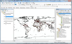
This cartography information is presented in a table where you just need to click on “File to download” from the layer you are interested in.
Remember that all cartography is offered in ETRS89 coordinates system and it will be downloaded in a compressed file (zip. format) that you need to decompress using a specialized program such as WINRAR.
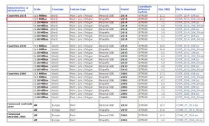
As an example, the CNTR_2014_03M_SH.zip file includes the following layers:
- layer with the country boundaries in polyline format
- layer with the countries in polygon format
- point layer of the capitals
It also contains a layer with labels of initials from the capitals of each country.
Enjoy!
Quality training taught by professionals
RECOMMENDED TRAINING COURSE


Hi Thank you very much for your work, for your kind notice the file CNTR_2020_03M_SH.zip contains only polylines not points and polygons. It would be helpful if updated.